Cristobal's Inland Track to Bring Heavy Rain, Gusty Winds and Isolated Tornadoes to the Midwest on Tuesday
Tropical Depression Cristobal will bring heavy rain, gusty winds and possible isolated tornadoes as it tracks farther inland through the Midwest on Tuesday.
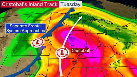
Cristobal's area of low pressure is centered in Missouri right now. It will track north-northeast across Wisconsin and the Upper Peninsula of Michigan through Tuesday night while transitioning into a non-tropical low-pressure system. That path is ahead of a frontal system approaching from the Plains, where wet and windy conditions are also expected today.
Interestingly, Cristobal is expected to be only the fourth Atlantic tropical cyclone remnant to move over Wisconsin in more than a century of records, according to the National Weather Service office in Milwaukee. If Cristobal remains a tropical depression when it crosses into Wisconsin, it would be the first tropical depression on record in the state.
Forecast
Cristobal is bringing rain and gusty winds to parts of the Mississippi and lower Ohio valleys this morning.
Cristobal or its remnants will spread rain and thunderstorms from parts of Missouri, Illinois and Indiana into eastern Iowa, eastern Minnesota, Wisconsin and Michigan through Tuesday night. Some of these areas could have at least localized flash flooding and strong winds.
A broader area of the Northern and Central Plains will also have rain, thunderstorms and gusty winds from the previously-mentioned frontal system.
NOAA's Weather Prediction Center says that Cristobal's remnants might produce storm total rainfall amounts of 2 to 4 inches (locally 6 inches) from Arkansas to the western Great Lakes.
The threat of flash flooding and river flooding has prompted the National Weather Service to issued flood watches from Missouri to parts of the upper Mississippi Valley. Portions of Nebraska and South Dakota are also under a flood watch.

The frontal system just to the west of Cristobal will also bring strong winds Tuesday to parts of the Plains. High wind warnings and wind advisories have been issued for those areas.
A chance of isolated tornadoes or damaging wind gusts could move into parts of the Midwest on Tuesday, particularly portions of Illinois, Indiana, western Kentucky, western Tennessee and southeastern Missouri.
There is a separate area of greater severe weather potential with the frontal system in northeast Kansas, southeast Nebraska, southwest Iowa and northwest Missouri. Those locations could see large hail, damaging wind gusts and anisolated tornado threat.

Comments
Post a Comment